ext and photos (c) Robert Barry Francos, 2010
Photos can be made larger by clicking on themDay 5 of our roadtrip was spent exploring some of the newer areas of Yellowknife (YK), the capital seat of the Northwest Territories (NWT). Yesterday went entered the city the "long way" along Old Airport Road, so today we took the more direct route around Jackfish Lake onto Highway 4, which turns into a road called Nivens Gate. We wanted to check out the Capital area of the city, which includes some striking architecture in some new buildings.
Our first stop was at the Prince of Wales Northern Heritage Centre, which is basically the area's keystone museum; however, we got there a half hour before it opened, so we decided to do some exploring in the area while we waited.
We set off on the path towards downtown that runs along Frame Lake, which borders the north side of YK's town center/centre. At the intersection of the Heritage Centre and the path is this North of 60 Degree Mining Memorial, dedicated to "the men and women who lost their lives in the mining industry in the Northwest Territories." Perhaps it should have said "the
Christian men and women..." as it seems other religions are not represented.
 Across Frame Lake was this lovely "United in Celebration" sculpture, representing the First Nations. We walked toward the new waterfront Somba K'e Park, where this was located.
 The flowers were lovely all along the path, and the light shining through them made a glow.
 Right off the lake was this piece of metal equipment within a tipi frame. Most likely it is some kind of mining equipment, but it sure looks like some of the deep sea fishing seats into which the fisher(wo)man locks their rod.
 Though establish in 2003, the Loraine Minish-Cooper Garden of Hope was in the process of being planted (re-planted?). It is multi-tiered with walkways, and when done will be quite a nice place to spend a lunch break, or see a concert.
 The area of the garden is sponsored by the Department of Defense, leading to an AEA-approved oxymoron photo, below.

 Here is an overview of the waterfront part of the park. Those benches, by the way, are the same ones used in downtown Saskatoon, from what I've been told.
 Directly across from the Garden of Hope is YK's City Hall. There are two sets of stairs leading up to the main door, the one on the left is still being built (or being replaced). We did not go inside, but it looks like a very modern office. There is some big money in this town, despite it's remote locale, thanks to mining, oil, and other industries. YK has one of the highest per capita average salaries in all of Canada.
 Directly in front of City Hall, on Veterans Memorial Drive, is this Nootka Totem Pole. It was built in 1971 by the Nitinaht Nation celebrating the 100 years of the formation of... British Columbia? While I don't understand why it is celebrating BC in the NWT, it is still a fine piece of work.
 Along the pathway near the park is this fire hydrant, with an amusing image of a dog doing its business.

 The Prince of Wales Northern Heritage Centre was open by this time, so we meandered back. The museum is free, with a request for donations, so I put in a Twoney ($2 coin). Prince Charles dedicated this building in person, so there is a huge painting of him by a horse near the entranceway.
 The back of the museum from the Frame Lake path.
 The first floor is a gradual ramp with different rooms housing maps, a full airplane (albeit a small one), mining logs and information, stuffed animals, videos, interactive exhibits, and many other interesting bits. I finished going through it in about an hour. My traveling companions, John and Ian, took twice as long.
 The left wall of the upper floor (image below) was a series of maps that stretched the entire Mackenzie River, which is enormously long. It is known also as Big River, or Deh Cho to the Dene Nation. John was particularly fascinated by this.
 One of my favorite pieces was this wooden carving known as Quiet Recollection, from 2001, carved from a single block of wood.
 While I waited for John and Ian to catch up, I leaned over the balcony and watched the museum's guard doing his thing. Seems like a good guy.
 Looking straight down from the balcony, I was able to see part of a stuffed Canada Goose, suspended by a wire.
 The cafe in the museum is quite popular among the locals, and we stopped off for a cuppa coffee (my second of the day, their third and fourth). Across the cafe is a huge window with a string of lights to symbolize the Northern Lights. They were not lit up during the day, but still looked intriguing.
 At this point, the battery in my camera was mort. Actually, both batteries were expended. The only way to charge them was in the car, and I had not had the chance to do that. So, I took out my partner's camera, a pocket model. It has a high rez (mine is 7.1, this is a 10.1), but the lens is not that great. You may notice the quality of the pictures change from this point for the rest of the day.
Our next stop was at the Legislative Assembly. Opened in 1993, it is a beautiful glass building that is identifiable from miles away. From the angle we came, it was hard to see through the foliage, so I took some pictures on the way out instead.
In the open-feeling lobby, are two maces, symbols of the Crown. The first one, below, has been in use since 2000. According to the official pamphlet, "The Mace reflects the Northwest Territories and is the symbol of the authority of the Legislature and its Speaker."
 Beside it is the retired Mace, which was used from 1959 until replaced by the one above. This one is actually a replica of the original used because that one is made of whalebone, and was cracking.
 The Great Hall where one enters the building has a glass wall that gives a feeling of openness and air, and when the sun streams through, this visitor felt the desire to take deep breaths.
 The center of the building is the Chamber, where the legislature meets. Behind the seats around the hall are interpreters for many of the local First Nations languages, who are represented by by 19 members. Note the polar bear rug in the center of the room. While visitors are not allowed on the main floor, there is a visitor's gallery where you can see the entire room.
 The big chair in the back is for the Speaker of the Assembly. When in session, the Mace is placed on the platform in front of the chair.

 In the antechamber to the Chamber was this roped off chair. This is the original Speaker's Chair, used from 1975 to 1993, a gift from the House of Commons and Senate of Canada. Again, note the place in front to house the Mace.
 Leaving the Legislative Building, you can see a hint of the domed roof over the Chamber.
 Walking along the trail to the next site, we again passed the 60 Degree Mining Memorial, as Ian reads the plaque.
 Our next stop was the YK Visitor's Centre, which is also a museum. When we entered, the person behind the counter gave each of us a Yellowknife label pin, which was a pleasant surprise. We glanced around the gift shop for a while but we didn't purchase anything (we were all on a budget); however, there was a computer there with some online info. I opened up a new window and checked my emails quickly, as I had not done that in five days. Also, I let my partner know where we were, and that we were safe. After that I logged out and closed the window.
 Inside the small museum part was an elevator to the second floor which took three minutes, because they showed a video about flying a plane in the NWT. The three of us were in there, and it was freakin' sweltering. We were happy it was no longer, and we could leave it before we passed out. Elsewhere in the museum were replicas of large diamonds that were found in the area, and a bunch of stuffed animals, including ptarmigans, a snow fox, a grizzly, and a Hugh Jack... I mean a wolverine.


 As we left, in the distance you could see the Legislative Building's dome.

 As we approached the back of the Hertiage Centre to get to our car, we saw this duck swimming around.
 By this time, we were hungry. We drove to the heart of downtown. This welcome sign is a major entranceway to the area.
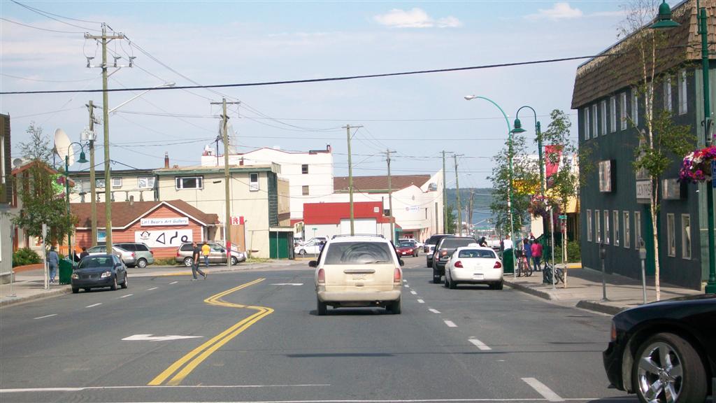
 As we drove along in the downtown area, along many walls were beautiful murals of different styles. Downtown is full of modern buildings. Looking to the east towards Old Town, Great Slave Lake is visible in the distance.


 The person who gave us the pins at the Visitor's Center had recommended the Black Knight Pub as a place for lunch. We walked in and I noticed that there was a lot of material about the New York Rangers hockey team. I asked the waiter, and he explained that the last owner, who had recently passed away, was a huge Rangers fan, and in his memory, they kept all of the memorabilia where it was.
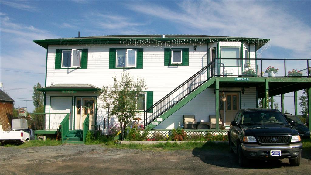
 One place we knew we had to see and do the mantatory tourist thing, was to go to the western edge of Old Town, and see Ragged Ass Road. This beautiful house is located there, with the street sign attached to the balcony.

 Here is another house with the sign. They kept getting stolen, so now anyone can buy an official city version of the sign at gift shops. We took pictures of each other in front of this one. Being a tourist can be fun.
 This house was one of my favorites on the street. Note the back porch, which had a wonderful view of Yellowknife Bay, on Great Slave Lake. Some of the houses in this area reminded me of those in the Hamptons on Long Island (NY), but without the rich pretentions; yards were filled with old cars and sheds, which would never be seen out in the Hamptons. People actually live here, not just for the summer.
 I liked both the angular blue house, and the greenhouses connected to the brown house next to it. These were on the far east end of Ragged Ass Rd, on the north side of the street.
 As one turns north after RAR ends, there are some Dene Nation houses, which are marked in contrast with those on the popular street.


 Reaching the main East-West road, a huge Dene symbol and a tipi frame mark the side of a hill. Just to the east of this was the Rock / Pilot's Monument. We had approached it from the North side yesterday, and today we were viewing from the south.


 We were out of the (white Coleman) gas that was needed for making morning coffee, so we traveled up to Old Airport Road, and made a few stops until we found some. Along the road, downtown was visible over the west arm of Frame Lake.
 We stopped into a few chain stores, and in one was a huge section dedicated to weaponry.


 After gettng some groceries for supper and breakfast, we headed back to camp for our last night in YK. I insisted we stop here so I can take this picture.
 That evening, we had some sad news that John's dog, Arlo, had passed away suddenly. John, Arlo and I had gone on a two-day drive in southern Saskatchewan to see ghost towns, Eastend, the Cypress Hills, and the Grasslands. He was a great dog.
After supper, I walked down to the beach again, by myself, and came back in time for bed.
Bonus pic: RIP Arlo.






 Posts

